Author: OpenStreetMap UK CIC
Board meeting 2019-09-02
Present: Rob Gareth Adam Jez Director resignationSteve Richardson has offered his resignation. Discussion around next steps, create an action to explore the options and present it to the members. Review […]
Board meeting 2019-08-05
Present: Rob Gareth Steve Jez (Joined during agenda item 1) Adam (Joined after 35 minutes) Martin (guest, for first 35 minutes) Update from Martin on TfL Cycle Infrastructure Database work: […]
Board meeting 2019-07-15
Present: Adam Rob (Chair) Steve Gareth Apologies: Jez Welcome to new Directors: Board would like to thank Brian and Gregory once again for their support. Welcome to Gareth and Steve […]
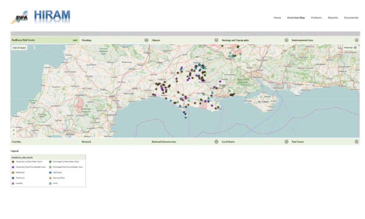
OpenStreetMap assists with Climate Change Resilience Planning
Responding to the increased frequency of weather-related road closures and the difficulty of securing government funding to mitigate the risks, a group of 14 councils organised in the South West […]
Board meeting 2019-05-08
Present: Rob Gregory Apologies: Jez Brian Adam AGM – Venue secured. Happy to confirm with members and talk-gb. Formal invitation to be drafted (Rob) and agreed with board via email. […]
St Albans Unlocked: Hearing OpenStreetMap through Soundscape
There are many people that live with sight loss for which taking a trip to shops or visiting a nearby tourist attraction can be stressful and often has to be […]
Birmingham City Council: leveraging traffic sensor data
Birmingham City Council redesigned their approach to intelligent mobility through the release of open data sets for traffic sensors using OpenStreetMap for speed, cost and open-ness. The publication of traffic […]

Augmented audio firm Third Skin join OSM UK
We continue to grow our corporate membership by welcoming Third Skin on board. Founded in 2015, Third Skin have developed Hy; a pair of ear-worn computers that augment your reality […]

OpenStreetMap’s response to the UK Geospatial Commission call for evidence
In late 2017 the UK Government announced the formation of a new Geospatial Commission to unlock the potential of geospatial data in the UK. At that time we set out […]

Revisiting addresses for the 2018 Q4 Quarterly Project
A modern map includes information about a whole range of things and OpenStreetMap is no different. Our dedicated community all love to add to the map and since 2015 we […]