Addressing addresses
What we’re doing
We are making it much easier to add addresses to OpenStreetMap.
How we’ll achieve this
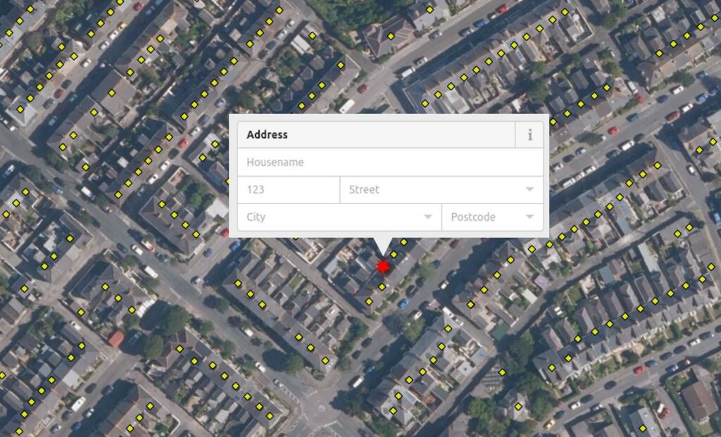
To make it easier for more people to collect and share addresses with us we intend to develop and host a website dedicated to crowdsourcing addresses. The user will be shown a set of point coordinates (Easting/Northing or Latitude/Longitude) where we believe there is an addressable location. By clicking on these points, the user will be prompted to enter the address details, as demonstrated in the image below. This could include the house number or name, the street name, the town or city and the postal code.
The point coordinates will be derived via an approach that uses data published under the Open Government Licence by Ordnance Survey Limited, HM Land Registry and Registers of Scotland. The exact approach that will be used has not yet been fully decided, however it is likely to be one of the following options, or a combination of the two.
Option 1: Cadastral polygons and building polygons
Under this option we will use multiple open datasets to derive a set of point coordinates representing likely addressable locations. We will use:
- Cadastral Parcels, of which there are two datasets: ‘INSPIRE Index Polygons spatial data’ published by HM Land Registry and the ‘RoS INSPIRE Cadastral Parcels dataset’ published by Registers of Scotland. Both datasets are published under the Open Government Licence.
- Generalised building outlines as published within either the ‘OS OpenMap – Local’ or ‘OS Open Zoomstack’ datasets, both published by Ordnance Survey Limited under the Open Government Licence.
By combining these datasets we will derive the point coordinates. This will be done by using the Cadastral Parcels to split (‘Clip’) generalised building outlines into their component parts. For example the Cadastral Parcels will enable us to split a terrace into its individual homes. The centroid of each split building will then be calculated.
Option 2: OS Open UPRN
Under this option, the point coordinates will be taken directly from the OS Open UPRN dataset. This is published by Ordnance Survey Limited under the Open Government Licence.
Why this is important to us
Here at OpenStreetMap United Kingdom, we strongly believe that access to free geographic data unlocks huge economic value to the UK. Indeed Accenture recently valued OpenStreetMap at $1.67 billion; this being the cost to replace the asset that our community, and the UK-registered OpenStreetMap Foundation (as the legal entity) makes available for free with an equivalent alternative.
UK address data is one of the key datasets that we believe can unlock further value if it was available as Open Data. In 2012 a report for Royal Mail’s PAF Advisory Board stated that UK address datasets contribute between £992m and £1.38bn to the UK economy per year. An economic assessment undertaken for the Open Data Institute explained that moving to free and open access can result in a threefold increase in demand for a dataset, thereby unlocking significantly more value to the UK economy.
Why we’re doing this now
Many have tried to make the case for a free and open list of UK addresses including their location. There is no doubt that this would benefit individuals and companies alike, however complexity and legacy arrangements have hindered progress to date. OpenStreetMap provides an alternative solution – one in which individuals and groups work together to collect and share their own data.
Time and time again, the OpenStreetMap approach has proven to be incredibly successful. It rapidly became one of the best visual display maps available. Navigation and routing enabled people to use OpenStreetMap to get from A to B so successfully that many ride-sharing companies are now using it. We also seen OpenStreetMap data used in augmented reality and gaming as well as supporting humanitarian relief efforts ensuring key workers can get help to the people that need it quicker.
One area that has been a little slower however, is address data. Over the 17 years that OpenStreetMap has existed, the community of volunteer contributors have crowdsourced circa 2.5m UK addresses (about 1 in 10). It’s not too surprising though; this has been achieved organically and without any coordinated effort. To help collect the rest at a faster pace we are now developing a website dedicated to crowdsourcing addresses. This will make it easier to contribute and enable many more people to contribute via a coordinated approach.
How you can help
If you are already familiar with OpenStreetMap please feel free to continue (or start) adding addresses via one of the existing map editors. For those that are new and find the existing OpenStreetMap editors too complex then we hope to have our new dedicated website available soon.